
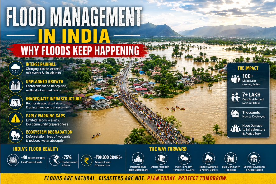
I still remember scrolling through photos from Sivasagar in early August 2026. A woman stood knee-deep in muddy water, holding her child above the flood. Behind her, an entire street had vanished beneath the Brahmaputra’s fury. That single image captures why Flood Management in India remains an urgent, unresolved national challenge. As I write this, Assam’s flood toll has crossed 100 deaths, and over 700,000 people have been displaced since July. Meanwhile, IMD warns of fresh heavy rainfall across Kerala, Uttarakhand, and Jammu & Kashmir in the coming days. So, here’s the question I keep asking myself: why do we still struggle with floods every single monsoon?
I don’t think the answer is simple. It’s not just about rainfall, and it’s not just about infrastructure either. Instead, it’s a tangled mix of geography, history, governance, and human choices. Consequently, this piece digs into why floods keep happening in India, and why disasters keep repeating despite decades of forecasting progress. I’ll walk you through the scale of the problem, the real causes, four revealing state case studies, and finally, solutions that actually work. Because honestly, understanding this mess is the first step toward fixing it.
The Scale of India’s Flood Problem
India does not have one flood problem. It has several, layered on top of each other. Central Water Commission (CWC) data spanning 1953 to 2019 shows that, on average, floods affect roughly 7.2 million hectares of agricultural and non-agricultural land every year. One state-level economic analysis using CWC’s damage records estimates that floods cause an average of 1,653 human deaths and total economic losses of around ₹3,612 crore annually, with crop damage alone accounting for roughly ₹1,119 crore each year between 1953 and 2011.
Zoom out further, and the picture becomes starker. A synthesis of 325 reported flooding events between 1950 and mid-2025 found that these events affected approximately 923 million people cumulatively, left around 19 million people homeless, and killed about 81,000 people. These are not the numbers of a single freak disaster; they describe a chronic, recurring hazard that has shaped Indian infrastructure planning for three-quarters of a century.
Crucially, these totals blend at least five distinct types of flooding: classical riverine floods on large basins like the Brahmaputra and Ganga; flash floods triggered by intense, localized rainfall, especially in steep Himalayan terrain; urban flooding driven by drainage failure and land-use change in cities; landslide-associated flooding in hill states; and coastal flooding linked to cyclones and rising seas. The National Disaster Management Authority (NDMA) treats urban flooding as a distinct category altogether, explicitly “delinking it from rural riverine floods” because the causes, dynamics, and required interventions are fundamentally different.
Why India Floods: Nature Meets Human Choices
Some flood risk is simply natural. India depends on the southwest monsoon for most of its yearly rain, packed into just four months. Intense rain spells, cloudbursts in steep terrain, cyclones on the coasts, and Himalayan snowmelt all create real hazards. Cloudbursts, defined in India as 100 mm or more of rain per hour over a small area, are now linked more often to flash floods and landslides in mountain regions.
But hazard alone does not equal disaster. NDMA’s own guidelines use a simple formula: Hazard plus Exposure plus Vulnerability equals Risk. Heavy rain and river overflow are the hazard. People and buildings in flood-prone land are the exposure. Weak infrastructure and poor planning are the vulnerability. Two places can get the same rainfall and still see very different outcomes, depending on exposure and vulnerability.
This is exactly what is happening across India today. Riverbank erosion keeps eating into settled land. Silt keeps clogging river channels. Deforestation and unplanned growth keep raising exposure, even as rainfall patterns shift. In fact, recent flood-landslide mapping research in Kerala found that exposure and vulnerability can shift risk hotspots well beyond what rainfall data alone would predict. In short, how India builds matters as much as how hard it rains.
Climate Change and India’s Shifting Flood Risk
Climate change is reshaping India’s flood risk, though not in the simple way headlines often suggest. One widely cited study found a threefold rise in widespread extreme rain events across central India between 1950 and 2015. This happened even as the region’s total monsoon rainfall was falling. Researchers traced the extra moisture to shifting wind patterns over a warming Arabian Sea.
A separate analysis of over a century of rainfall data, from 1901 to 2020, found a clear rising trend in extreme rain across most Indian regions. This trend closely tracks land-use change alongside broader climate shifts. Meanwhile, a tehsil-level study covering more than 4,500 sub-districts found that 55% of tehsils saw rainfall rise by over 10% between 2012 and 2022, compared to the prior three decades. Nearly a third of tehsils gained four or more extra heavy-rain days each year. This pattern strongly links to flash floods.
Even El Niño years, usually tied to drought in India, seem to carry hidden flood risk. As researcher Spencer Hill of the City College of New York put it after a 2025 study in Science: “Our key finding is that you tend to get more days with extreme amounts of rainfall within India, not less, during El Niño summers”. His team found these extremes clustered in central India and along the southwest coast, exactly where major floods keep striking.
Still, not every flood traces back to climate change. Mean monsoon rainfall has actually dropped over the Indo-Gangetic plains and northeast India in recent decades, even as extremes rise elsewhere. Scientists caution that land-use change, aerosols, and natural swings all interact with warming to shape these patterns. What is clearer is this: much of India’s flood infrastructure was built for an older, calmer rainfall pattern. That pattern no longer matches today’s sharper, more concentrated downpours.
Four States, Four Lessons in Flood Management
Assam, Kerala, Uttarakhand, and Jammu & Kashmir have all flooded hard in recent years. Yet each state reveals a different piece of India’s flood puzzle.
Assam shows what happens when a river outgrows its defences. The Brahmaputra, one of Asia’s largest rivers, floods low-lying char islands and embanked floodplains nearly every monsoon. Riverbank erosion keeps eating settled land. Silt keeps shrinking channel capacity. As a result, communities get pushed back into the same flood corridors, often because there is nowhere else to go. By August 9, 2026, the state’s toll stood at 100 deaths, with the Brahmaputra sweeping away homes and damaging roads across roughly 900 kilometres inside Assam. This is a story of embankments meeting their limits against a river that keeps shifting course.
Kerala shows what happens when extreme rain meets a changed landscape. Even though average monsoon rainfall has fallen over parts of the Western Ghats, heavy-rain days have risen. That combination raises the odds of sudden landslides and flash floods, especially where wetlands and watershed buffers have steadily eroded from urban and farm expansion. Kerala’s lesson is clear: non-structural tools, like watershed protection and land-use rules, matter just as much as river engineering.
Uttarakhand shows how development can outrun safety margins. Roads, hydropower projects, and tourism have pushed settlements onto unstable Himalayan slopes and narrow river corridors. This is exactly where short, intense rain does the most damage. Cloudburst-driven debris flows can overwhelm drainage within minutes. That leaves little time to evacuate, even when warnings exist.
Jammu & Kashmir shows how cities quietly destroy their own flood buffers. Nearly all of Jammu city’s roughly 150 ponds have shrunk. Unplanned growth has turned many former wetlands into dumping grounds. Combined with heavy rain and weak drainage, this loss of natural storage has made the city far more vulnerable to both river floods and local waterlogging.
What Each State Reveals About India’s Flood-Management Problem
| State | Primary Hazard | Key Amplifying Factor | Core Lesson |
|---|---|---|---|
| Assam | Basin-scale river flooding (Brahmaputra) | Riverbank erosion, siltation, char settlement | Embankments alone cannot contain a shifting river |
| Kerala | Extreme rainfall, landslides (Western Ghats) | Wetland loss, watershed degradation | Land-use rules matter as much as engineering |
| Uttarakhand | Cloudbursts, flash floods | Roads, hydropower, tourism on unstable slopes | Development often outpaces warning lead times |
| Jammu & Kashmir | River and flash flooding | Loss of ponds and wetlands to unplanned growth | Destroying natural buffers turns rain into disaster |
Source: State disaster management authority reports; Down To Earth water-body survey; IJCRT cloudburst and flood-risk review, 2025–2026
Land-Use Change and the Urban Flooding Trap
If land floods again and again, why does India keep building there? The evidence points less to ignorance and more to weak enforcement. NDMA’s own guidelines name floodplain zoning, the legal limit on construction in high-risk zones, as a core flood-management tool. Yet studies of Indian cities show construction and drainage changes happening in exactly the zones flood maps flag as dangerous.
Bengaluru makes this clear. Research on the city found that frequent flooding since 2000, even during normal rain, comes directly from lost wetlands, more paved surfaces, and cut links between lakes that once absorbed excess runoff. As a result, urbanised catchments can push flood peaks up to three times higher than natural land. Flooding can now strike within minutes of heavy rain, not hours. Alongside floodplain zoning, water conservation measures such as reviving urban ponds and lakes can restore the natural storage capacity that cities have paved over.
Chennai tells a similar story at a bigger scale. The city lost roughly half its water bodies between 1911 and 2004, according to a Down To Earth investigation. Its stormwater network covers only 855 kilometres, against 2,847 kilometres of city roads. Drains meant to link lakes have themselves been built over and need constant desilting.
Gurugram, often called a “Millennium City,” faces the same pattern. As the Haryana State Disaster Management Authority noted in 2020: “Gurugram faces recurrent waterlogging and flooding due to unregulated construction, encroachment on natural drains, and poor stormwater management”. Construction on the Badshahpur drain and the shrinking Basai wetland has cut the city’s natural flood buffers. Meanwhile, split control across multiple city agencies makes coordination even harder.
NDMA is direct about this problem. Urbanisation can raise flood peaks by 1.8 to 8 times, and flood volumes by up to 6 times, compared to natural catchments. That is precisely why standard flood-control infrastructure often fails in fast-growing cities.
Can India Predict Floods? The Last-Mile Warning Gap
India’s forecasting system is stronger than most people assume. The IMD issues district-level rain forecasts. The CWC runs a national network of river gauges and forecasting stations. In fact, CWC alone issues more than 7,000 flood forecasts and warnings each year across India’s river basins. During the current Assam crisis, IMD gave specific, multi-day lead times, warning of “fairly widespread to widespread rainfall” over Arunachal Pradesh, Assam, Meghalaya, and neighbouring states through mid-August.
So why doesn’t good forecasting always prevent disaster? The answer lies in what we can call the last-mile warning problem. Information must travel from forecast to Government warning, to District administration, to Local authority, to Community, to Individual. At each step, the message can slow down, lose detail, or simply fail to reach people without smartphones, steady power, or local-language alerts. NDMA’s community guidelines call for multilingual campaigns, pre-set shelters, and trained local volunteers. But implementation still varies sharply between well-funded urban wards and remote rural districts.
This distinction matters. India increasingly has a warning system that predicts hazard days ahead. However, it still lacks a full warning-to-action system, one where every household in a flood zone knows exactly when to leave and where to go. On the science side, new research into Kerala’s flood-producing weather patterns suggests better medium-range forecasts are possible. That could give districts more lead time, but only if the science reaches local alert systems.
Structural vs Non-Structural Measures, and Who Answers for What
India’s flood strategy has long leaned on structural fixes: embankments along the Brahmaputra and Ganga, dams and reservoirs on major basins, and city drainage channels. These tools work, but they have limits. Embankments can breach, silt up, or create false confidence that draws more settlement behind them, exactly the pattern visible in Assam’s char areas. NDMA’s guidelines now push for non-structural tools too: floodplain zoning, forecasting, evacuation planning, wetland protection, and smarter land-use rules, used alongside structural investment, not instead of it.
Reservoir and dam management deserves careful treatment here, because public debate often blames dam releases for floods without solid evidence. Government reports stress the need to link real-time rain forecasts with reservoir decisions and downstream warnings. Yet public data on operating rules, pre-monsoon flood cushions, and inter-state coordination remains limited. Fair reporting should separate documented mismanagement from unverified claims, since heavy rain and saturated catchments are often the bigger driver, even when a release coincides with flooding.
Behind all this sits a governance system with overlapping duties. Disaster management, including urban floods, is a state subject under India’s constitution. The central government, through NDMA, CWC, and IMD, mostly issues guidelines, forecasts, and technical support. States and city governments handle the ground work: maintaining drains, enforcing building rules, and running emergency operations. This split is not automatically broken. Still, it creates real gaps, uneven zoning enforcement, inconsistent local capacity, and weak accountability for whether guidelines actually get followed.
Structural vs Non-Structural Flood Management in India
| Category | Examples | Strength | Key Limitation |
|---|---|---|---|
| Structural | Embankments, dams, drainage systems, river training | Cuts flood extent and depth quickly | Can breach, silt up, or invite risky settlement nearby |
| Non-structural | Floodplain zoning, forecasting, wetland protection, evacuation planning | Reduces exposure and risk long-term | Needs steady enforcement and local capacity, often missing |
Source: NDMA National Guidelines on Management of Floods (2008) and NDMA Community-Based DRR Guidelines (2024)
Who Is Responsible for What in India’s Flood Governance
| Tier | Primary Responsibility |
|---|---|
| Central Government (NDMA, CWC, IMD) | Forecasting, technical guidelines, funding, capacity building |
| State Government | Disaster policy, embankments, inter-district coordination |
| District Administration | Evacuation, relief camps, local warning delivery |
| Urban Local Bodies / Panchayats | Drainage upkeep, zoning enforcement, building-rule compliance |
| Communities | Preparedness, early response, acting on warnings |
Source: Ministry of Home Affairs parliamentary replies (2016, 2021); NDMA Urban Flooding guidelines
What Actually Works: Evidence-Based Solutions
None of India’s flood problems are unsolvable. But generic checklists rarely build real resilience. The evidence points to specific, priority fixes.
On risk reduction, three steps stand out. First, enforce floodplain zoning with real legal teeth. Second, fold existing flood-risk maps into local development plans. Third, apply risk-aware building codes in known flood corridors. Together, these steps would directly cut future exposure.
On nature-based solutions, restoring wetlands and river corridors helps too. Reviving traditional water bodies, as NDMA’s own guidance recommends, can recover storage capacity that costly drains struggle to replace. On infrastructure, catchment-based drainage design matters most. Paired with strict pre-monsoon desilting deadlines, it tackles one of the most common causes of urban flooding.
On technology, three tools show promise. Wider Doppler radar coverage improves rain tracking. Stronger GIS-based risk maps guide planning. And new flood-susceptibility models, already piloted in Kerala’s Western Ghats using AI methods, can sharpen forecasts at the district and ward level. Stronger rainwater harvesting policies by the government, paired with strict compliance checks at the building-approval stage, could meaningfully cut peak runoff in India’s fastest-growing cities. On community readiness, the basics still work best: marked evacuation routes, trained local volunteers, multilingual alerts, and shelters people can actually reach. Reducing water contamination after floods requires safe-water protocols, from emergency chlorination to protecting handpumps and wells from floodwater intrusion, alongside the drainage and zoning fixes discussed above.
Evidence-Based Solutions: What Works and What Limits It
| Solution | Evidence of Effectiveness | Main Limitation |
|---|---|---|
| Floodplain zoning enforcement | Central to NDMA’s framework; prevents new exposure | Enforcement varies widely across states |
| Wetland and water-body restoration | Documented storage loss in Chennai, Bengaluru, Jammu | Requires reversing decades of encroachment |
| Catchment-based drainage upgrades | Cited as a core failure point in urban flood studies | High cost, slow municipal execution |
| AI/ML flood-susceptibility mapping | Piloted successfully in Kerala’s Western Ghats | Not yet mainstream in daily forecasting |
| Community-based evacuation preparedness | Linked by NDMA to fewer casualties | Needs steady local funding and training |
Source: NDMA Community-Based DRR Guidelines (2024); Down To Earth urban water-body survey; Kerala flood susceptibility modelling research (2024)
Governance reform ties all of this together. Annual, public flood-preparedness audits at the district level would help. So would transparent flood-risk maps open to both citizens and builders. Most of all, India needs a real commitment to “Build Back Better“, rebuilding roads, embankments, and homes so they can survive the next flood, not just replace what was lost. Together, these steps could shift flood spending from reactive relief toward lasting risk reduction.
Choosing Resilience Over Repetition
Let’s return to that woman in Sivasagar, standing in floodwater with her child. Her story will repeat next monsoon, and the one after, unless something genuinely changes. Flood Management in India cannot remain a reactive relief exercise triggered only after disaster strikes. As long as hazard, exposure, and vulnerability keep aligning across our floodplains and hillsides, floods will keep happening. However, choosing resilience means enforcing zoning laws, restoring wetlands, and closing the last-mile warning gap before the next crisis, not after it. India has the science, the guidelines, and increasingly the technology; what remains is the collective will to act on all three, together, before the next monsoon arrives.
At ExpressIndia.info, we believe informed citizens build resilient nations – so let’s demand the flood management India deserves, starting today.
#FloodManagementIndia #AssamFloods2026 #ClimateResilience #UrbanFlooding #DisasterPreparedness