
Glacial monitoring in India confronted its gravest test, and it failed. However, the reckoning arrived from a neighbouring nation’s anguish instead. The morning of 26th August 2026 started, for most people in the Bhotekoshi valley, like any other. By nine a.m., it wasn’t. A slope somewhere above the Lhende Khola gave way — ice, rock, and half-frozen debris crashing down together — and within minutes the river had a new, temporary dam it never asked for. Eighteen hours later, that dam broke. What came down the valley afterward killed over 1000 people and swept away nearly 4,000 more (numbers at the time of writing this blog), many of them Indian tourists who had crossed the border expecting a holiday, not a headline.
I’ve read a lot of disaster coverage over the years, but this one stopped me mid-scroll. Not because of the scale, though the scale is staggering, but because of the daunting visuals and the eerie familiarity. Three years earlier, in October 2023, Sikkim went through its own version of this exact story — a lake giving way in the dark, a warning that never reached the people who needed it, a government left explaining what happened rather than preventing it. Two disasters, three years apart, and the same unanswered question sitting underneath both: does glacial monitoring in India actually function as an early-warning system, or is it mostly a very sophisticated way of documenting catastrophes after they’ve already happened?
That question forms the crux of this blog. It matters because the easy, comfortable answer — “we need better monitoring” — turns out to be almost useless once you look closely. India already monitors glacial lakes. It has satellites, atlases, risk classifications, entire government programmes built around exactly this problem. The uncomfortable answer is more specific and less flattering: knowing where the danger is has never been the same thing as being ready for it. This is an investigation into that gap in glacial monitoring in India — what it tracks, what it missed in Sikkim, what’s quietly accumulating in Arunachal Pradesh, and what it would actually take to close the distance between watching a lake and warning a village.
What Actually Happened in Nepal — and Why the Label Matters
Within a day of the Rasuwa flood, most headlines had already reached for the familiar shorthand: GLOF, glacial lake outburst flood. It’s a clean, quotable term, and it fit the general shape of what everyone was seeing on video — a wall of water and debris tearing through a Himalayan valley. There was just one problem. It was probably wrong.
The US Geological Survey’s later analysis found something the early reporting had missed entirely. The seismic signal that everyone assumed was an earthquake — the kind of reading you’d expect from tectonic plates shifting — had actually come from somewhere else: a massive glacial collapse, ice and rock breaking free and slamming into the valley below with enough force to register on seismographs built to detect continental movement. That’s not a subtle distinction. A true GLOF starts with a specific, mappable lake breaching its banks. What happened at Rasuwa started with an unstable slope that wasn’t, as far as anyone can tell, sitting directly above a known glacial lake at all.
ICIMOD‘s rapid field assessment, along with Nepal’s disaster management authority, pieced together a version of events that looked more like a chain reaction than a single event. Ice and rock plunged into the Lhende Khola. The debris blocked the river’s flow, forming an improvised dam nobody had engineered and nobody was monitoring. For the better part of a day, that dam held — and then, roughly eighteen hours later, it didn’t, releasing a debris-choked torrent that had been building pressure the entire time.
Why does the terminology matter so much, beyond scientific pedantry? Because if you keep calling every Himalayan flash flood a “GLOF,” you start looking for the wrong warning signs. You watch the lakes and miss the slopes. Nature’s own coverage of the disaster put it about as bluntly as a science journal ever does: early warning could have saved hundreds of lives, and the reason it didn’t wasn’t a lack of general awareness — high-risk conditions across the wider Himalayas were already well documented. It was a failure to translate that awareness into something that reaches people in time.
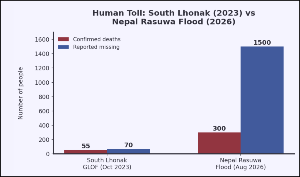
Source: News18, The Wire, ACAPS Sikkim briefing note, and Nepal 2026 flood coverage via Kathmandu Post and ICIMOD;
Note: The toll figures for Nepal Rasuwa flood are only the initial reported numbers.
Borders Don’t Stop Rivers
Here’s the part that should keep Indian policymakers up at night: the flood that devastated Rasuwa didn’t even originate in Nepal. It started in Tibet, crossed into Nepal, and by the time it reached its full force, three Indian states — Bihar, Uttar Pradesh, and West Bengal — were on high alert, bracing for floodwaters moving down the Gandak river system. NDRF teams didn’t deploy as a courtesy. They deployed because a mountain collapse eight hundred kilometres away had suddenly become India’s problem too.
Chinese authorities, for their part, confirmed the formation of a barrier lake near the Chhochen Khola–Purepu Tsangpo confluence — millions of cubic metres of water held back by nothing more permanent than loose debris, with a real risk of its own eventual breach. Picture that chain for a second: a glacier collapses in a remote stretch of the Tibetan plateau, a flood tears through Nepali villages a day’s journey away, and evacuation orders go out on the Gangetic plains of Bihar before the week is over. That’s not a hypothetical sequence of events about “interconnected ecosystems.” That’s what actually happened, in real time, this year.
Union Minister Kiren Rijiju, addressing the disaster’s implications for India, struck a reassuring note: “Administration and the NDRF arrangements are there. Any natural disaster that happens to us, India already has preparations to handle natural disasters.” He wasn’t wrong, exactly — the NDRF response was real and it was fast. But reassurance after the incident happens is a different proposition from prevention beforehand. Hence, his own statement, read carefully, concedes the point: India was responding to a crisis, not anticipating one.
ICIMOD has spent years cataloguing dozens of what it calls “potentially dangerous glacial lakes” scattered across the shared mountain systems of Nepal, India, and China — water bodies whose failure wouldn’t respect a single national boundary. Treat Himalayan glacial risk as someone else’s domestic issue, and you’ve already lost the argument. These systems don’t check passports. If a slope collapse in Tibet can put Bihar’s floodplains on alert within a single news cycle, then cross-border data sharing isn’t some diplomatic nicety to be negotiated at leisure — it’s closer to basic public safety infrastructure.
The Surprising Part: India Actually Does Monitor This
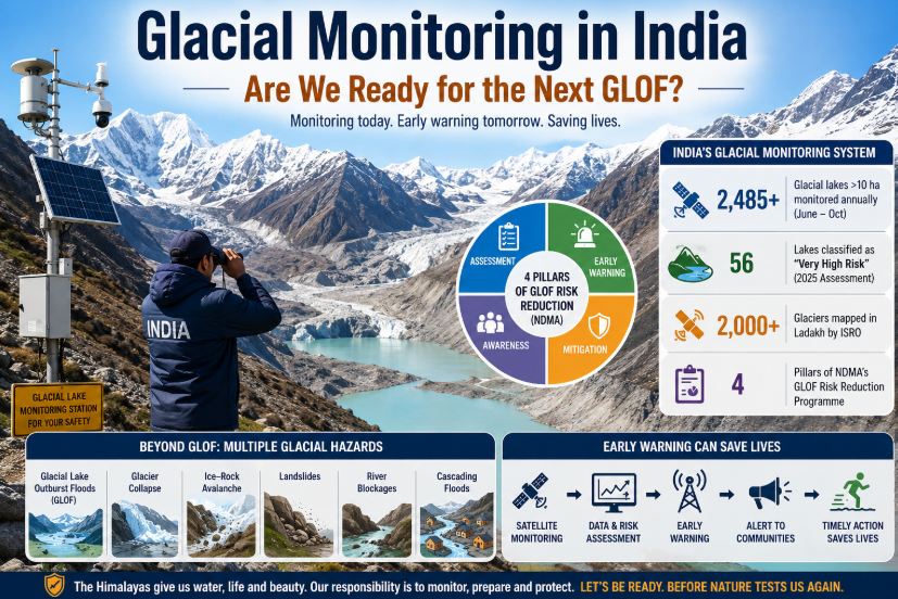
Here’s what tends to get lost in the panic after any Himalayan disaster: India isn’t starting from zero. Not even close. The Central Water Commission maintains a Glacial Lake Atlas covering the Himalayan river basins, and its most recent reports track 2,843 glacial lakes and associated water bodies through remote sensing, updated annually. A 2026 reply in the Lok Sabha went further, specifying that the Ministry of Jal Shakti actively monitors 2,485 lakes larger than ten hectares, every single year, from June through October — precisely the window when melt and monsoon rainfall make these lakes most volatile.
That same parliamentary reply contained a more pointed number. A 2025 scientific assessment had classified fifty-six of those lakes as “very high risk,” weighing GLOF potential against the exposure of downstream towns and infrastructure. Read that again: India’s own government already knows, with some precision, which fifty-six lakes are the most dangerous. The data isn’t the missing piece.
ISRO fills in a complementary role, using satellite imagery to track lake expansion, glacier retreat, and shifting snow cover across terrain that would take ground teams weeks to reach on foot, if they could reach it at all. Dr. Jitendra Singh, Minister of State in the Prime Minister’s Office, told Parliament that ISRO has “generated a database of more than 2,000 glaciers” in Ladakh alone, with GLOF risk modelling already complete for several of the highest-risk lakes there. Layer on top of that the National Disaster Management Authority’s dedicated GLOF Risk Reduction programme — built around four pillars of assessment, early warning, mitigation, and community awareness — and you get an institutional picture that looks, on paper, genuinely comprehensive.
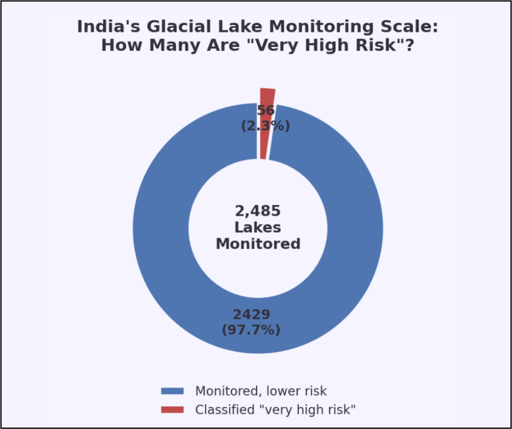
Source: Ministry of Jal Shakti, Lok Sabha reply (2026), reported via Economic Times.
| Agency | Core Role in Glacial Monitoring | Key 2025–26 Data Point |
|---|---|---|
| Central Water Commission (CWC) | Glacial Lake Atlas, remote sensing (June–Oct) | 2,485 lakes >10 ha monitored annually |
| ISRO | Satellite mapping of glaciers, lakes, snow cover | 2,000+ glaciers mapped in Ladakh alone |
| NDMA | National GLOF Risk Reduction Programme | 56 lakes classified “very high risk” (2025) |
| MoES / NCPOR | Cryosphere research, glacier behaviour studies | Ongoing snow-glacier dynamics research |
Source: Ministry of Jal Shakti Lok Sabha reply (2026); ISRO/Lok Sabha reply via Dr. Jitendra Singh (2026); NDMA NGRMP document (2025).
So why does it keep going wrong? We can spot a lake swelling from four hundred kilometres up in orbit, with remarkable precision, and yet somehow still fail to get a ten-minute warning to the village sitting directly downstream of it. That gap — between what a satellite can see and what a human being on the ground actually knows — is where this entire investigation lives.
Sikkim, Three Years On: What Did We Actually Learn?
To understand that gap properly, you have to go back to the night of 3rd October 2023, when roughly 14.7 million cubic metres of frozen moraine gave way and dropped into South Lhonak Lake. What happened next unfolded with almost mechanical cruelty: a tsunami-like wave nearly twenty metres high slammed into the lake’s frontal moraine, tore through it within minutes, and released about fifty million cubic metres of water — roughly half the lake’s entire volume — into the valley below.
The numbers that followed are the kind that don’t fully register on first reading. Around fifty-five people dead, dozens more never found. Nearly twenty-six thousand buildings damaged or destroyed. Thirty-one major bridges gone. The flood eroded some 270 million cubic metres of sediment on its way down, travelling 385 kilometres through the Teesta valley and out into Bangladesh before it finally lost its force. The flood erased Teesta III, a 1,200-megawatt hydropower project that had taken years and enormous capital to build, within hours.
Dr. Ashim Sattar, a glaciologist at IIT Bhubaneswar who led the definitive forensic study into what happened, told Carbon Brief afterward that “there are many, many factors that came together here” — though permafrost thaw, in his analysis, was clearly the dominant driver. What he said later, in an interview with News18, is the line that has stayed with me since I first read it: “the changed slope may cause more failures,” he warned, because the moraine “is now steeper than before the 2023 collapse.” Ponder on that for a moment. The mountain that broke once is now more likely to break again, not less.
And here’s the part that turns this from tragedy into indictment: Scientists had flagged South Lhonak, for years, as one of the most hazardous, fastest-expanding glacial lakes in the entire Sikkim Himalaya. Everybody who studied it knew it was dangerous. Nobody had installed a dedicated early warning system there. When the wave finally came, it was Indo-Tibetan Border Police personnel downstream, not any sensor or automated alert, who first realised something catastrophic was underway — because they saw it with their own eyes, in real time, with no advance notice whatsoever.
What changed afterward has a certain bitter irony built into it. Regulators eventually mandated a Telemetric Early Warning System as a condition for rebuilding Teesta III — real-time monitoring of water levels, rainfall, and seismic activity, exactly the kind of system that might have made a difference in 2023. That’s genuine progress. It’s also proof of a pattern that shows up again and again in disaster policy everywhere: the alarm gets installed right after the house has already burned down, and it protects one project rather than the entire basin it sits in.
Arunachal Pradesh Is Quietly Running the Same Clock
Sikkim understandably dominates the national conversation about GLOF risk — it has the casualty numbers, the destroyed hydropower plant, the forensic papers in international journals. But while attention stays fixed there, Arunachal Pradesh has been accumulating its own risk profile largely out of public view.
A 2026 peer-reviewed study used satellite imagery spanning nearly four decades, from 1988 through 2020, and applied a structured risk-ranking method — the Analytic Hierarchy Process — across 127 glacial lakes in the state’s Eastern Himalayan stretch. The two factors that mattered most, unsurprisingly, were lake expansion rate and proximity to glaciers: the exact combination that doomed South Lhonak. Of those 127 lakes, researchers classified two as unambiguously high risk, thirty-six as medium risk, and the remaining eighty-nine as low risk.
A separate, more targeted study zeroed in on the Mago Chu basin in Tawang district, examining five specific lakes already flagged as high-risk. Four of those five had measurably expanded between 2016 and 2026. That’s not a distant, theoretical possibility sitting in an academic paper somewhere — it’s an active trend, documented over a single decade, in lakes that already carry a dangerous classification.
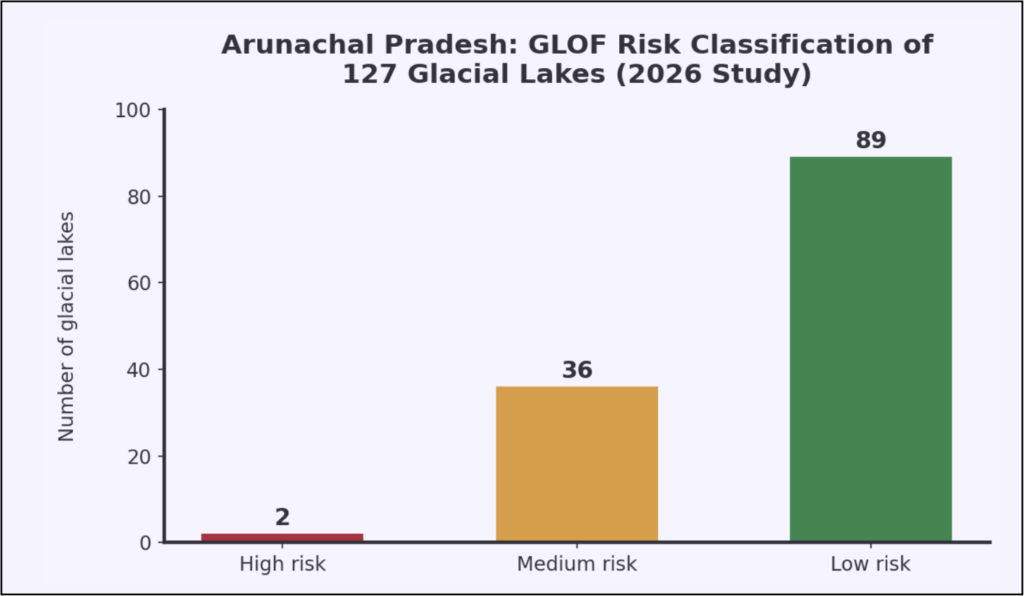
Source: 2026 peer-reviewed AHP-based glacial lake risk assessment, Springer (Eastern Himalaya study).
| Risk Category | Number of Lakes (Arunachal Pradesh, 2026 study) |
|---|---|
| High risk | 2 |
| Medium risk | 36 |
| Low risk | 89 |
| Total assessed | 127 |
Source: 2026 peer-reviewed AHP-based glacial lake risk assessment, Springer (Eastern Himalaya study).
The obvious question is why this matters to anyone outside Tawang’s remote valleys. It matters because downstream communities across Arunachal Pradesh, and parts of Assam further along the river systems, sit directly in the path of anything these lakes might eventually release. And because these lakes haven’t had their South Lhonak moment yet, public pressure for dedicated monitoring investment here stays muted in a way it never could in Sikkim after 2023. Arunachal Pradesh’s glacial lakes deserve the same scrutiny Sikkim now gets — ideally before, rather than after, they force the issue themselves.
It’s Not Just About How Big the Lake Is
One of the most persistent misconceptions in this entire conversation is that lake size alone predicts danger. South Lhonak disproved that decisively. The more revealing variable, researchers increasingly argue, is moraine stability — the frozen, ice-rich material damming a lake in place, which can quietly destabilise over years of permafrost thaw without any visible change on the surface. Sattar’s study found the South Lhonak moraine had been creeping at up to fifteen metres a year in the period before it finally gave way. Nobody translated that slow, patient warning sign into meaningful preventive action.
Proximity to glaciers matters just as much, since retreating or thinning ice destabilises the slopes sitting above these lakes in ways that aren’t always obvious from satellite imagery alone. Add avalanche potential, seasonal snow accumulation, and melt timing to the list, and the monitoring checklist grows considerably longer than a simple question of surface area. NDMA’s own GLOF programme calls for exactly this kind of integrated assessment — physical lake parameters combined with downstream exposure, rather than either factor considered in isolation.
And that downstream half of the equation deserves equal weight. Population centres, roads, bridges, hydropower infrastructure — all of it sits exposed in these valleys, and yet many risk assessments still lean disproportionately on lake size as the primary metric. International hydropower guidance now explicitly urges building GLOF and debris-flow scenarios directly into project design, not treating them as an afterthought bolted on once construction is already underway. Otherwise, as South Lhonak proved, you can spend years measuring the wrong variable while the real danger accumulates quietly in the moraine above.
Monitoring Is Not the Same Thing as Warning
This is the argument this entire piece has been building toward, and it deserves to be stated without qualification: knowing that a dangerous lake exists protects absolutely nobody by itself. Researchers documented, studied, and flagged South Lhonak as hazardous for years before it failed. None of that documentation stopped the flood, because nobody had connected it to an automated alert that could reach anyone in time. Nepal’s 2026 disaster occurred in a similarly well-mapped, high-risk basin, and the outcome was the same — downstream communities got essentially no real-time warning before the water arrived.
Think of what genuine safety actually requires as a chain with several distinct links: satellite observation, risk assessment, real-time monitoring, early warning, communication, evacuation, and finally, resilient infrastructure that can absorb whatever gets through. India has built formidable capability in the first two or three links of that chain. Everything after that remains patchy, improvised, or in some places simply absent. Mongabay’s investigation into South Lhonak found that no automated warning system alerted dam operators in time, precisely because none existed at the lake — despite its well-documented volatility. NDMA’s own programme documents openly acknowledge this weakness, calling explicitly for stronger last-mile communication through sirens, SMS alerts, and community drills.
Acknowledging a gap on paper, though, is a different exercise entirely from doing the harder, less glamorous work of actually closing it. This isn’t India’s first reckoning with the gap between knowing a hazard exists and warning people in time — our earlier investigation into Flood Management in India: Why Floods Keep Happening found the same disconnect driving India’s recurring monsoon flood disasters.
What Building the Missing Piece Would Actually Look Like
So what would it take to close that gap for real? Start with near-real-time satellite monitoring for the highest-priority lakes — moving beyond CWC’s current periodic remote sensing toward something closer to continuous surveillance during the riskiest months. Layer automatic lake-level sensors and rainfall gauges on top of that, feeding into centralised platforms rather than sitting in isolated reports. Add seismic monitoring capable of distinguishing a genuine earthquake from a glacial collapse — precisely the confusion that muddied the early hours of Nepal’s disaster.
Cameras at the small handful of genuinely high-risk lakes — South Lhonak, the Mago Chu basin sites in Tawang — could catch morphological changes before they become catastrophic failures. Downstream, river-level sensors already feed into CWC’s existing flood-forecasting systems; connecting those to GLOF-specific alerts would let warnings travel automatically rather than depending on border police personnel spotting a flood wave with their own eyes. Sirens, SMS alerts, and cell-broadcast systems need to reach villages within minutes of a detected threat, not hours after the deluge.
There are real, encouraging signs that this is beginning to happen. Uttarakhand has announced plans to deploy satellite imagery, drones, and sensor networks specifically to improve glacial lake flood warnings — a template other Himalayan states could reasonably copy. Teesta III’s reconstruction now mandates a permanent Telemetric Early Warning System monitoring water levels, rainfall, and seismic activity in real time. These aren’t just policy documents gathering dust; they’re concrete, funded steps. But they remain isolated pilots scattered across different states and projects, not one connected national network — and isolated pilots, however well-intentioned, simply cannot protect a mountain range this vast.
The Question Hydropower Keeps Avoiding
Nobody particularly enjoys saying this plainly, so I will: India keeps building hydropower projects in exactly the valleys where glacial hazards are most concentrated. Engineers had built Teesta III’s sixty-metre dam to withstand extreme water floods, the kind of flooding hydrologists had modelled for decades. It could not withstand a sediment-choked, debris-heavy GLOF surge, because nobody had designed for that specific failure mode. The dam failed within hours, and Teesta V suffered serious damage alongside it.
Peer-reviewed research is now blunt about the pattern this represents: expanding hydropower capacity near glacier lakes doesn’t just coexist with risk, it actively compounds it. To their credit, regulators absorbed that lesson at Teesta III, mandating a redesigned concrete gravity structure alongside the new real-time monitoring system before allowing the project to resume operations. But broader industry analysis still lists numerous major projects across Arunachal Pradesh, Sikkim, and Jammu and Kashmir as similarly exposed — the lesson learned at one site hasn’t yet become the standard applied everywhere else.
Which raises the question policymakers can’t keep dodging indefinitely: are Himalayan dams, tunnels, and bridges being designed for the climate India is actually entering, or for historical hydrological averages that no longer reliably hold? Every project approved without an explicit multihazard assessment is, in effect, a bet against future glacial instability. Given what both South Lhonak and Rasuwa have now demonstrated, that remains a genuinely dangerous wager to keep making.
Toward Something That Actually Works
India isn’t missing the raw materials here. NDMA’s GLOF and landslide risk programmes exist. CWC’s monitoring architecture exists. ISRO’s satellite capability exists. What’s missing is the connective tissue that would bind these pieces into one functioning system, rather than several well-funded initiatives operating largely in parallel. Institutional coordination between CWC, ISRO, MoES, NDMA, and state disaster authorities needs to be formalised as standard practice, not assumed to happen through informal goodwill between departments.
Funding needs to move past the pilot stage and toward sustained infrastructure across every high-risk basin — not just the ones that have already made national headlines. Cross-border data sharing with Nepal and China deserves formal, standing protocols rather than the reactive coordination that tends to emerge only once a crisis is already underway. And community-based preparedness — drills, evacuation routes, clear signage, genuine local awareness of what a warning siren actually means — needs to become a routine part of district-level disaster planning, not an emergency improvisation assembled after the fact.
Updated infrastructure standards should require multihazard risk assessments for every major Himalayan project without exception: hydropower, roads, bridges, border infrastructure, all of it. India has clearly demonstrated it can identify and monitor these lakes at scale. The test that actually matters now is whether that monitoring can reliably become a warning that reaches a village, a dam operator, or a bridge engineer minutes before disaster strikes — not days after, once the reconstruction contracts are already being drawn up.
Because the next glacial hazard, wherever it originates, won’t send a press release first. India’s Himalayan communities deserve a system that can outrun the mountain’s silence, rather than one that simply explains, with admirable precision, what the mountain has already done.
Where Glacial Monitoring in India Leaves Us
Glacial monitoring in India has genuinely matured over these past few years — the satellites are better, the atlases more detailed, the institutional programmes more ambitious than they were even a decade ago. But Rasuwa and South Lhonak, three years and one border apart, both prove the same uncomfortable point: data without delivery saves nobody nestled in a valley at two in the morning. The states along this mountain range — from Sikkim’s glacial lakes to Arunachal Pradesh’s quietly expanding ones — deserve a system built to warn them well in advance, not simply to explain, with great scientific precision, what happened to them.
For researchers, planners, and the policymakers who will eventually have to sign off on the budgets this requires, consider this blog less a warning and more a working blueprint. The chain from satellite to siren is incomplete, but every piece of it already exists somewhere in India’s institutions. What’s missing isn’t technology or knowledge. It’s the political will to connect what India has already built.
If you live anywhere downstream of a Himalayan river, or you know someone who does, this is worth five minutes of your time: write to your local MP and ask, plainly, what early warning infrastructure exists near the nearest high-risk lake to where you live. Share this with someone who needs to ask that question too. Awareness moves faster than floodwater, but only if enough people decide to spread it that way.
ExpressIndia.info refuses to accept another Rasuwa, another South Lhonak, another village that finds out too late — the time to build the warning is now, not after the water arrives.
GlacialMonitoringInIndia #GLOFRisk #HimalayanGlacialLakes #SikkimFloods #ArunachalPradesh #WithNepal